-
Hashtag= #bluemarble
Background:
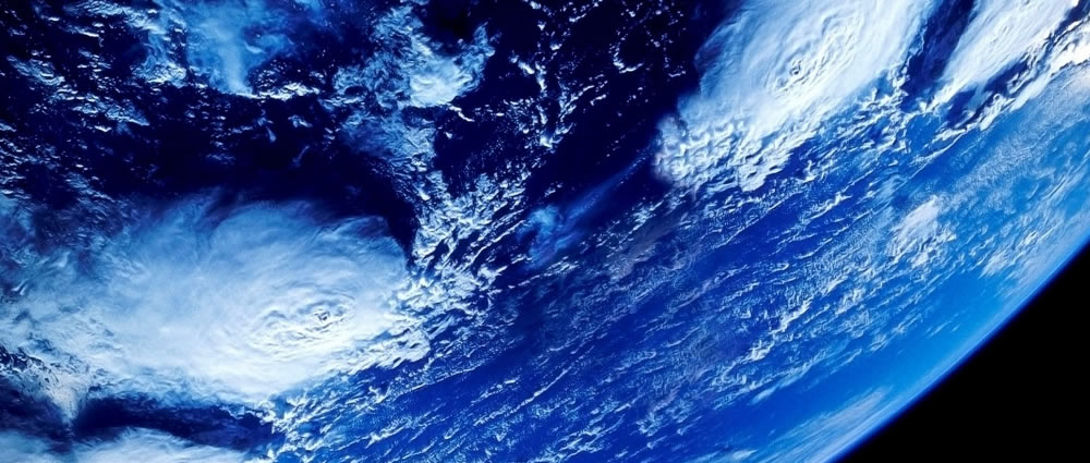
The first photo of Earth from space was taken on October 24, 1946, from an altitude of 65 miles above the surface of New Mexico. It was captured by a 35-millimeter motion picture camera as that camera was propelled skyward on a German V-2 missile.
However, most people recall of the iconic Blue Marble - a famous photograph of the Earth, taken on December 7, 1972, by the crew of the Apollo 17 spacecraft, at a distance of about 45,000 kilometres (28,000 mi).
Since spaceflight began, millions of photos have been taken of Earth from space, many of these images are never seen by a wider audience.
Challenge Description:
Create an app, platform or website that consolidates a collection of space imagery and makes it more accessible to more people.
Functional Specifications:
Many photos do not have location information or meta information. Develop a way to geotag the photos as well as assign it a description of the country, area, or region featured.
Consider ways to make the data more interactive, potentially through the use of social media, gamification, crowd-sourcing, or citizen science applications.
Develop an API for this platform that allows others to utilize the great data in a more accessible format as well.
Datasets
-
Gateway to Astronaut Photography of Earth
-
NASA.gov Imagery Index
-
Human Spaceflight Gallery
-
NASA on Flickr
-
NASA Imagery
-
Scripts
blankhttp://eol.jsc.nasa.gov/scripts/sseop/QuickView.pl?directory=ESC&ID=ISS027-E-36162
http://www.flickr.com/photos/astro_andre/6661535367/in/set-72157628937567511/
http://eol.jsc.nasa.gov/scripts/sseop/QuickView.pl?directory=ESC&ID=ISS028-E-24377
http://eol.jsc.nasa.gov/scripts/sseop/QuickView.pl?directory=ESC&ID=ISS027-E-6252
-
234,118 Image Dataset (CSV)
http://data.spaceappschallenge.org/Images.zipA zip file with 234,118 image links and metadata. Fields are as follows:
mission – shuttle or station mission identifier – AS = Apollo, GEM = Gemini, personally, unless these images were really good I’d skip these, NASA and NM are NASA-Mir (Shuttle visiting the Mir space station), SL is Skylab, the rest are Shuttle or ISS.
roll – camera roll number/name
frame – frame #
width – of the image
height – of the image
filesize – of the image
CLDP – cloud cover percentage (I think. Kim?), yep, that’s right
Lat – latitude (of the thing photographed) latitude of the center point of the image, not the “thing”
Lon – longitude(of the thing photographed) longitude of the center point of the image, not the “thing”
geon – geographic name (of the thing photographed)
feat – any features (of the thing photographed), well features at the center of the image, then working outwards if notable -
234,118 Image Dataset (JSON)
http://data.spaceappschallenge.org/images_json.zipThe same data that is in the CSV dataset, formatted as a JSON array of objects rather than a CSV file.
Create Project Solving this Challenge
Need help?
Check out the comments to chat with other users working on this challenge or email the challenge creator with any questions.
-
-
The following projects are solving this challenge:
-
ISAC #010
Our solution is a website for rating images from space which we have acquired by scraping the nasa image website for pictures and meta-data Visit Project
-
Blue Marble
Goal of this project is to texturize the Globe using imagery of Earth taken from space. Crowd-sourcing will be used for content creation. Visit Project
-
NASA Globetrotters
We want to make cataloging earth imagery fun for everyone. Users will place earth imagery on top of a globe in the correct geographic location to earn points. Play against your friends on Facebook! First person to one million points wins a Rogers t-shirt (size small)! Also providing a R... Visit Project
-
Satellap - API And Interactive Blue Marble Images
It is a webpage that displays the images in an Earth Map.. It is categorize by Missions For now!... We will also be creating API for simplified access of this data Visit Project
-
Earth Images
A web application that provides that consolidates a collection of space imagery and makes it more accessible to more people. Visit Project
-
The Blue Marble Project
A simple website where users can discover new faces from our world in a fun way. our home. Visit Project
-
ESIH Space Explorer
This web application allow user to explore the NASA database of picture on a user friendly way. User have access to a Time Line of picture and can see the location of the picture on a MAP. Visit Project
-
NASA Pic of the Day
We want to create a Mac and Windows app to update your desktop wallpaper daily with the NASA Image of the Day (<http://www.nasa.gov/multimedia/imagegallery/iotd.html>). Visit Project
-
Home Planet
Allows users to interact with the photos and learn more about the Earth, using a webapp in the form of a profile. Visit Project
-
imgspace
This app gives the an easy, funny and interactive experience to the final user and also encourages the final user´s curiosity about space and astronomy using for this photographic captures. We achieve this developing a website where the final user can surf, explore and search for interesting i... Visit Project
-
overview
Who are you? Alexandru Dancu, planet Earth, student Evita Lanka, developer, Liepāja, Latvia Kane, electronic music producer, Bristol, UK Paul Nader, Marble developer, Bristol, UK What is your role in the Space Apps Challenge? Alex, Evita and Paul developed it. Kane contribute... Visit Project
-
Le Big Blue
App to Solve the Big Blue Earth Challenge Visit Project
-
Where on the Blue Marble?
# VOTE FOR US NOW # Please press the green button at the top of this page or click [HERE](https://twitter.com/intent/tweet?text=I%20vote%20%23whereonmarble%20for%20%40spaceapps%20People%27s%20Choice%20Award!) to vote for us by sending a simple tweet. # ASTRONAUT PHOTOS # After 50 years o... Visit Project
-
Space Decode
Extended Project Decription ====================== SpaceDecode aims to raise space exploration awareness (also addressing the blue marble challenge) by using artificial intelligence to find images that relate to NASA's missions and operations, and make them globally accessible in a simple and f... Visit Project
-
lebluemarvel
Upon launching the desktop **lebluemarvel**, it displays lots of balls on a black background: that's how we abstract space. The balls come in different colors and sizes and they move at different speeds. Each ball represents an image that is displayed once the ball is clicked. The attributes of t... Visit Project
-
PicStoria
Picstoria is a "taggable" visual database of approximately 300,000 pictures of the Earth from Space, accumulated since 1946, aiming at solving The Blue Marble challenge. Picstoria provides an interactive visual timeline of world events and pictures from space associated with them. Each entry incl... Visit Project
-
The Big Marble
The project came to be when a couple members of our team tried to use the NASA websites to find images of their houses from space. After much frustration, we found pictures but were unhappy with the presentation and with the overall difficulty of obtaining the information. The pictures we found w... Visit Project
-
The Blue Marble
Loading...
×
Loading...
×